Greenland’s dying ice

A project to monitor every aspect of a fast-shrinking glacier could hold an answer to an urgent question: How fast will seas rise?

10 October 2019

This summer, as meltwater streamed off the Greenland Ice Sheet in record amounts, a ramshackle research ship, the Adolf Jensen, sat idling in this fjord, icebergs near its bow and a mystery below it. Two years earlier, oceanographers had moored a sensor in the fjord's depths to decipher how warm Atlantic Ocean waters are eroding Helheim Glacier, one of the ice sheet's largest tongues. But now they couldn't retrieve the 500-meter-deep mooring—or its crucial data.

On deck, under a late July sun, Fiamma Straneo, a physical oceanographer at the Scripps Institution of Oceanography in San Diego, California, glared at a yellow box at her feet. It was blasting acoustic chatter at her mooring, telling a latch to let go, but the signal seemed to fall on deaf ears. "Time to come home," she said hopefully. The minutes ticked by and the mooring didn't surface. Straneo grimaced. Over the past decade, she has used such moorings to collect a long-term record of water masses and currents in Sermilik Fjord, a 90-kilometer-long passage, wider than the Mississippi, that ushers melting icebergs from Helheim out to sea and warm water back in. The stuck mooring threatened to leave a gap.

It was an inauspicious start to an ambitious project. Even after decades of study, researchers can't say how quickly the Greenland Ice Sheet will melt under the strain of human-driven global warming. Melt from Greenland already accounts for 25% of global sea level rise, double the contribution of Antarctica, and its share is growing. Rising waters are already exacerbating storm surge and causing sunny-day flooding in cities worldwide. Even by conservative estimates, Greenland could contribute another quarter-meter of sea level rise by 2100—within the lifetime of children living today. All told, the ice sheet holds enough water to raise seas by 7 meters—and no one knows whether, or how fast, that water will be unleashed.

As befits its mythical name, the domain of the Norse god of the dead, Helheim is truly an arbiter of Greenland's fate. The glacier is one of the ice sheet's primary drains, sliding into the sea at 8 kilometers per year and accounting for 4% of the ice sheet's annual mass loss. Its towering front, as tall as the Statue of Liberty, measures 6 kilometers across. Sea ice shed from the glacier chokes the fjord for tens of kilometers. The glacier's terminus has behaved erratically over the past 15 years, first retreating by 5 kilometers from 2002 to 2005 and then advancing and stabilizing for nearly 10 years. Then, in 2014, a more severe retreat began, sending the terminus 2 kilometers beyond its previous low. Meanwhile, the glacier has thinned by more than 100 meters, leaving a telltale "bathtub ring" high on the rock around the fjord.

Some two-thirds of Greenland's ice loss comes not as meltwater, but as chunks of ice that detach, or calve, from its 300 outlet glaciers—fast-moving rivers of ice that end in long fjords. Those narrow channels, hundreds of meters deep, "are the bottlenecks," Straneo says. They also are a fateful meeting place, where a glacier's calving front encounters currents of increasingly warm ocean water. "These tiny systems are the connection between the ice sheet and the ocean," she says.

Straneo's past work showed that warm Atlantic water is penetrating Sermilik Fjord, which researchers once thought was dominated by Arctic waters. Here, it meets cold meltwater draining through channels beneath the ice. Straneo believes the emerging freshwater, buoyant because of its low salinity, mixes with the warm water and forms a plume that wells up against the glacier's front, causing more melting and fracturing. It's like the ice in your glass of whiskey, she says. "If you just put it in and don't stir, it lasts a long time. If you stir it, it melts really quickly."

Greenland’s Sermilik Fjord is choked with ice from the fast-retreating Helheim Glacier. Warm waters deep in the fjord are helping to erode it. P. VOOSEN/SCIENCE

To test the idea, she and colleagues need to go further, breaching Helheim's protective veil of sea ice to observe the warm plume directly. They also must track the behavior of the glacier itself in exacting detail.

The effort began this year: a 4-year, $6 million project financed by the Heising-Simons Foundation in Los Altos, California. The project, modest in cost by Arctic standards, is attacking Helheim from every angle: drilling into firn—snow that has not yet compacted into ice—to gauge how much mass southeastern Greenland's famously severe storms add to Helheim. Placing seismometers at the glacier's terminus to sense the spread of hidden fractures. Recording the glacier's calving four times a day with a pair of autonomous lasers, dubbed Atlas. Air-dropping hardened drifters that can capture conditions near the glacier front while surviving encounters with icebergs. Placing moorings up and down the fjord to probe its depths. And knitting all those observations together with advanced models of glacial fracturing.

Beyond Helheim, what Straneo and her peers find could feed into something grander: an international long-term observing system to monitor and assess the risks posed by the melting of Greenland's most prominent glaciers. That endeavor could dispel much of the uncertainty about Greenland's role in future sea level rise.

On arriving in Greenland, the team had a reminder of the urgency. A heat wave in Europe was forecast to reach them soon, causing melt unseen since 2012. And Straneo had heard that something phenomenal was happening up at Helheim's front. A surge of meltwater was pouring out at the bedrock, pushing open a 500-meter-wide half-moon of water in the shadow of the glacier's towering face. The effect had created a direct route to sampling the waters below. Such upwellings typically reach the surface for just a day or two. This plume's size suggested it might last weeks.

This summer, oceanographers aboard the Adolf Jensen (left) measured conditions deep in the fjord with moored instruments and a “carousel” of sensors and sample bottles (right). (LEFT TO RIGHT): DAVE SUTHERLAND/UNIVERSITY OF OREGON; P. VOOSEN/SCIENCE

STRANEO STARTED HER LIFE far from ice. Like many smart students in Italy, she was directed into physics. But she loved to sail and found herself drawn to the ocean and its large-scale currents, first as a modeler and then as a field scientist. She spent much of her academic life at the Woods Hole Oceanographic Institution in Massachusetts, and it was there, some 15 years ago, that she met Gordon Hamilton, a glaciologist at the University of Maine in Orono.

At the time, Hamilton and his student, Leigh Stearns, had begun to place GPS units on Helheim to track its startlingly rapid retreat. Helheim was a scientific backwater. It does not have the easy logistics that the National Science Foundation provides for researchers working on Greenland's western coast, and frequent North Atlantic storms blanket it in snow, making it harder to study than the glittering flat ice of the west.

Straneo had been focused on ocean currents, such as the "conveyor belt" that influences climate around the North Atlantic. But Hamilton convinced her that the smaller-scale currents in fjords could be key to an equally important process: Greenland's ice loss. In 2008, she and colleagues, including Hamilton, spent a season in Sermilik Fjord. They hired a small boat and dropped temperature and salinity sensors into the fjord on a fishing line, anchoring their moorings with cinder blocks.

Those first casts clearly showed something unexpected was going on. Scientists once thought the fjord would be filled with water that flows down from the Arctic, hugging Greenland's coast. But the measurements pointed to two layers of warm water in its depths: a deeper layer apparently heading up toward Helheim and a shallower one, cooler and less salty, heading back to sea. The deep flow was likely Atlantic water, ushered in by summer winds. The shallower flow seemed to originate as the warm water interacted with the ice, losing heat and salt in the process.

Year after year, Straneo returned to the fjord. Meanwhile, Hamilton's frustration with the limited data from the GPS units grew. Then, he met David Finnegan, a remote sensing scientist at the U.S. Army's Cold Regions Research and Engineering Laboratory (CRREL) in Hanover, New Hampshire, who uses reflected laser light to map terrain. What if they used such a laser to constantly monitor Helheim's front? Tying together such fracturing with the influx of Atlantic water could help them figure out what role, if any, the water plays in the loss of ice.

Northern watch

The Greenland Ice Sheet, which holds enough water to raise the seas by 7 meters, loses much of its ice through 300 glaciers, which flow into long, narrow fjords and break up into icebergs. But scientists have struggled to understand how human-driven warming drives such fracturing, making predictions of future sea level uncertain. At Helheim Glacier and its fjord, Sermilik, scientists have begun a campaign to track every part of the melting system to find patterns relevant across all of Greenland.

Dwindling giant

Helheim is one of Greenland’s largest outlet glaciers, draining 4% of its ice. It has retreated 7 kilometers since 2002, thinning by more than 100 meters.

Atlantic invasion

Sermilik Fjord was once thought to be filled with frigid Arctic water. Researchers have now shown that a deep layer of warm water from the Atlantic is infiltrating all the way to Helheim’s face, a 100-kilometer journey.

An opening

This summer, a mixture of subsurface melt and warm Atlantic water led to a weekslong pool of open water at Helheim’s face–a rare chance to probe the fjord’s depths.

Turbulent mix

At Helheim’s base, a channel of meltwater flushes into the fjord. This meltwater, naturally light, drags warm Atlantic water up along Helheim’s face.

C. BICKEL/Science

In 2012, Finnegan's team perched a prototype autonomous laser scanner on one of the fjord's walls, overlooking Helheim's terminus. The scanner played a beam of infrared light across the glacier, its front, and the sea ice, tracking the calving process iceberg by iceberg. The data dropped jaws when Finnegan presented them at a meeting in 2013. This was big data come to glaciology, each reflected point tied to coordinates in space—as though the team suddenly had one million GPS units on the glacier at once.

Even with those two complementary lines of evidence, Helheim's ice loss defied explanation. "Each year was kind of different," says Stearns, who is now at the University of Kansas in Lawrence. Figure out a mechanism for 1 month, and a year later it was irrelevant. Too many variables, such as the flow of meltwater under the glacier and the temperatures beneath the sea ice, could not be tied down. Only a sustained monitoring system, targeting every element of the glacier and fjord, could show how the system delivered ice from the glacier to the ocean and how a warming climate might influence it.

That vision took a step toward reality just after Finnegan's talk, when Cyndi Atherton approached him. Atherton, who had joined Heising-Simons to direct its scientific grants, wanted to fund research that could make a room gasp. "What would you do with a blank check?" she asked. Heising-Simons began to finance the development of the Atlas scanners, which could capture the entirety of Helheim's crumbling tongue from perches on both walls of the fjord.

Three years into the work, tragedy struck: Hamilton died in 2016, at 50 years old, after his snowmobile fell 30 meters into an Antarctic crevasse. The researchers left behind hardened their desire to understand Helheim. Last year, Heising-Simons asked Straneo and Stearns to assemble a team that would tie down all Helheim's variables at once. The project would be a proof of principle, Atherton said, "that will allow other governments to say this is valuable, and we're going to extend from this site to other sites."

The work began this summer.

Fiamma Straneo, a physical oceanographer, in a helicopter collecting water samples from the pool at the terminus of Helheim glacier (left). The researchers also used the helicopter to place small seismometers on the fractured ice near the glacier’s calving front (right). (LEFT TO RIGHT) DONALD SLATER; P. VOOSEN/SCIENCE

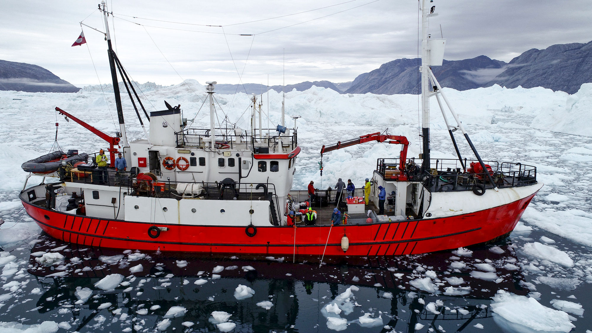
THE 39-METER Jensen, a former Danish fisheries research ship and icebreaker, is far removed from large modern oceanographic ships, where scientists rarely get to touch an instrument. Its crew of five Greenlanders keeps it 
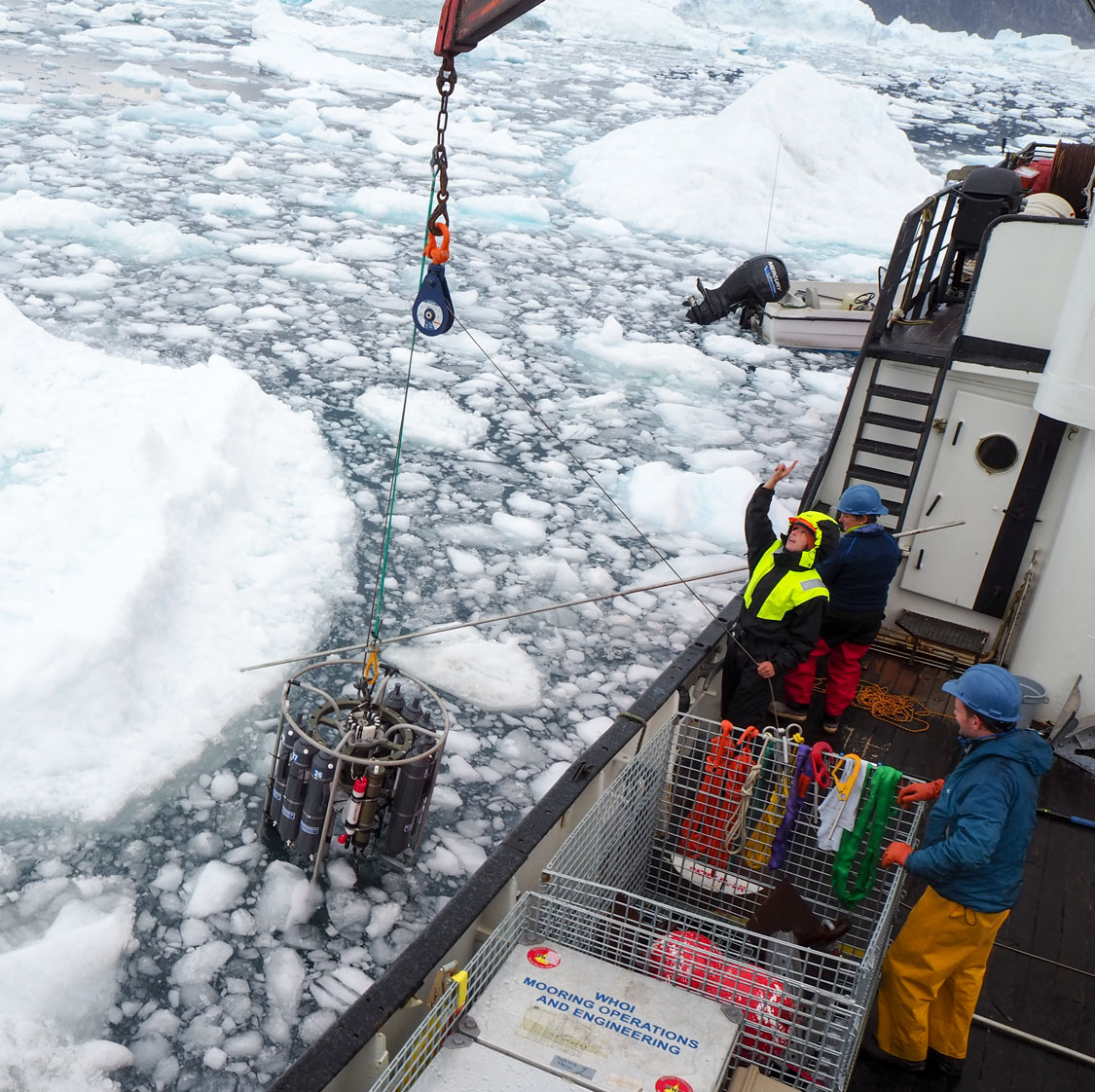
running with a mix of grease, tobacco, and gumption. The scientists, too, have to improvise around limitations such as the Jensen's 1960s vintage winch. When the team retrieves the carousel, a gray cylindrical frame outfitted with sensors and large sampling bottles, the winch is too feeble to hoist it on deck. That means an awkward transfer to the ship's crane.

It's just how the modest Straneo—who has had the same blue fleece since she was 18—likes it. "We still do oceanography the old-fashioned way," she says. "You kind of have to do everything yourself."

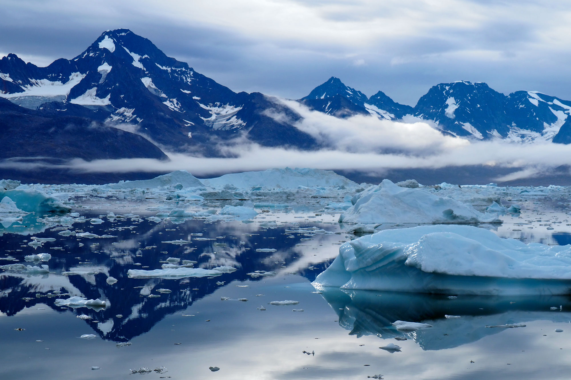
The Jensen had taken a back route from the port of Tasiilaq in southeastern Greenland, threading through narrow channels before sailing out into Sermilik Fjord. Peaks towered on both shores. A thin fog filtered cathedral light onto glass-still water. To the west, the ice sheet bulked vast and gray behind the peaks. Icebergs, most calved by Helheim, were constant companions—some white, some sparkling blue, some sooty black—often dwarfing the Jensen as it steered around them like a tugboat around an oil tanker. Every so often, the quiet was broken by the waterfall rush of violence as icebergs flipped over, agitated by the ship's wake.

Beyond collecting and placing long-term moorings, the team wanted to measure the salinity and temperature of the water column within the fjord, as far north as the ice would allow. The work has its hazards: One year, the ice was so thick on the way to retrieve a mooring that the captain had a panic attack and turned back. A few days later, an iceberg destroyed that mooring. But Straneo was confident that the old icebreaker was up to the task.

After she could not retrieve the first mooring, three others came back with little drama, their spherical red-and-white floats popping up near the ship. Each mooring monitored a different depth to capture the Arctic-fed water near the surface and the Atlantic layers beneath it. "It looks so easy when they come up," Straneo said. "And it's so painful when they don't."

After several days in Sermilik's midsection, the Jensen steamed closer to Helheim. The icebergs and their detritus grew denser, until the fjord seemed more ice than water. A mate climbed to the crow's nest to spot hazards, and the Jensen began to plow through human-size bergs to avoid their larger cousins. Finally, the ice defeated the crew. Helheim's cliff face, some 25 kilometers away, loomed into view for a few minutes before a fairy-castle iceberg obscured it.

The approach was close for Straneo, but it still left a large gap in her data. This year, other opportunities to fill it would come along. Her collaborators would launch a long-lived drifter that can navigate beneath sea ice. And, after the cruise, Straneo's team planned to take a helicopter out to the open pool and drop sensors straight into the plume of meltwater.

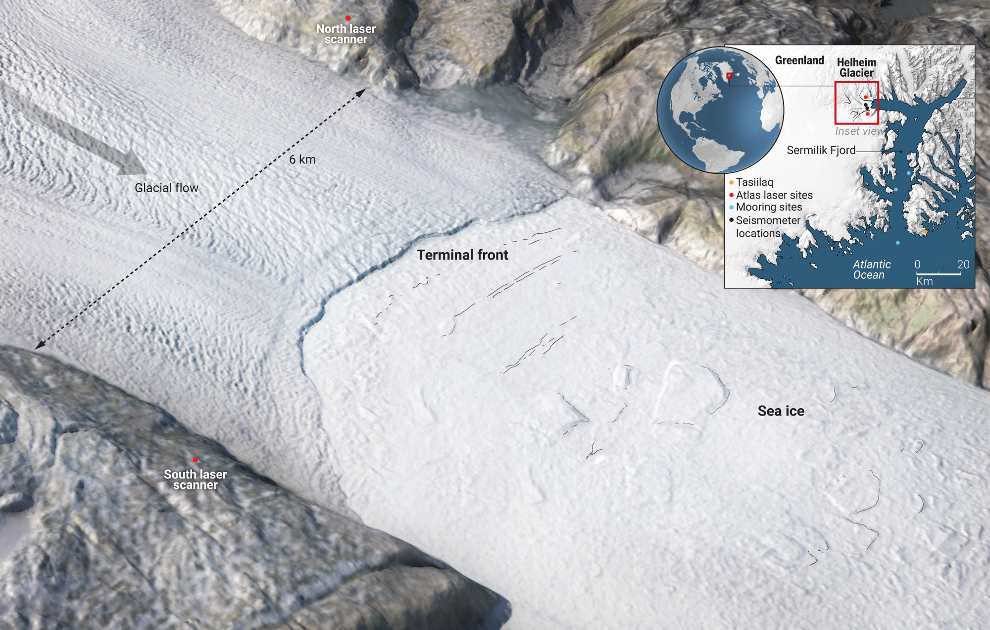
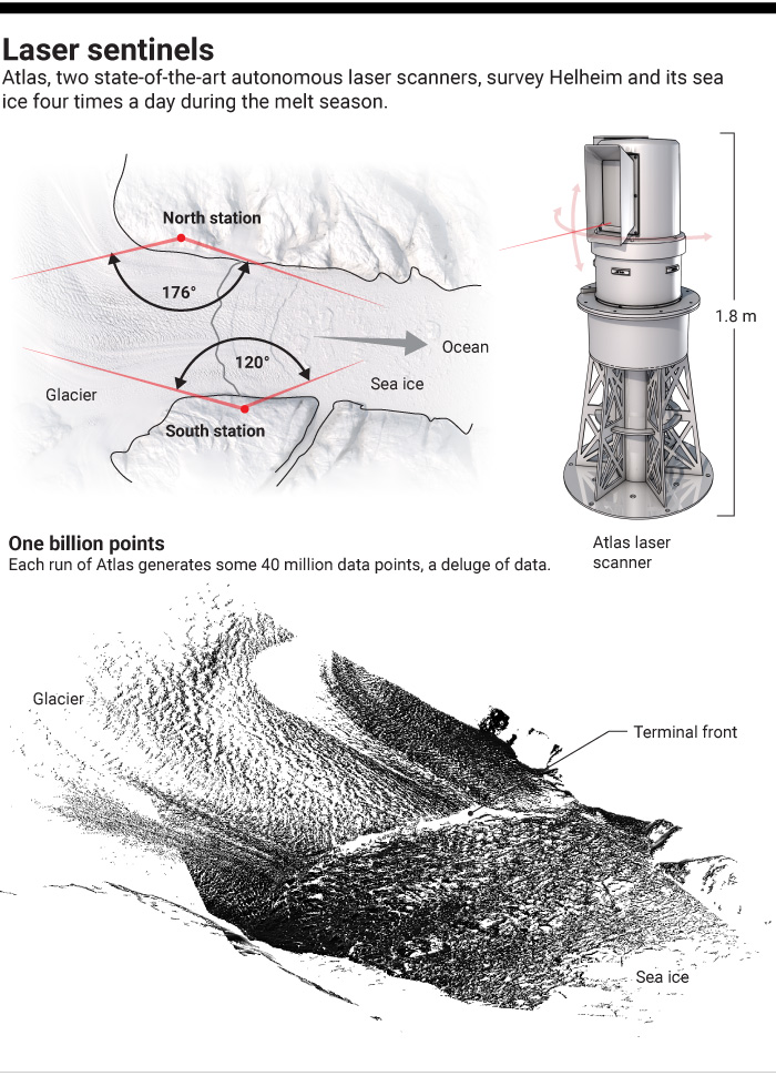
EVEN AS THE Jensen navigated the fjord, two teams monitored the glacier itself. Near its front, Finnegan and the CRREL scientists tended to the autonomous Atlas lasers, one mounted on each side of the fjord. The researchers had also agreed to help Sridhar Anandakrishnan, a glacial seismologist at Pennsylvania State University in State College, deploy 15 small seismometers, called geopebbles, on the glacier just behind the calving front—a feat possible only from the air.

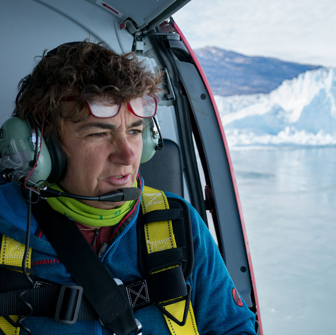
After a career working in Antarctica, it was Anandakrishnan's first experiment in Greenland. In the helicopter, his eyes widened on seeing the glacier. It was nothing like the flat, solid marine glaciers in Antarctica. Helheim was gouged with crevasses some 20 to 30 meters deep; its southern flank was such a crumpled mess that it was hard to tell where the glacier stopped and sea ice began. "It's so spectacular," he said. "It's so scary."

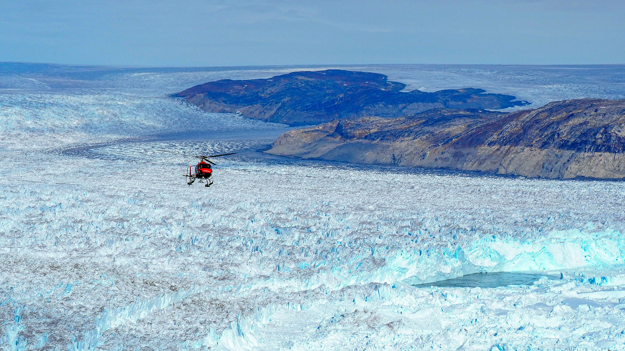
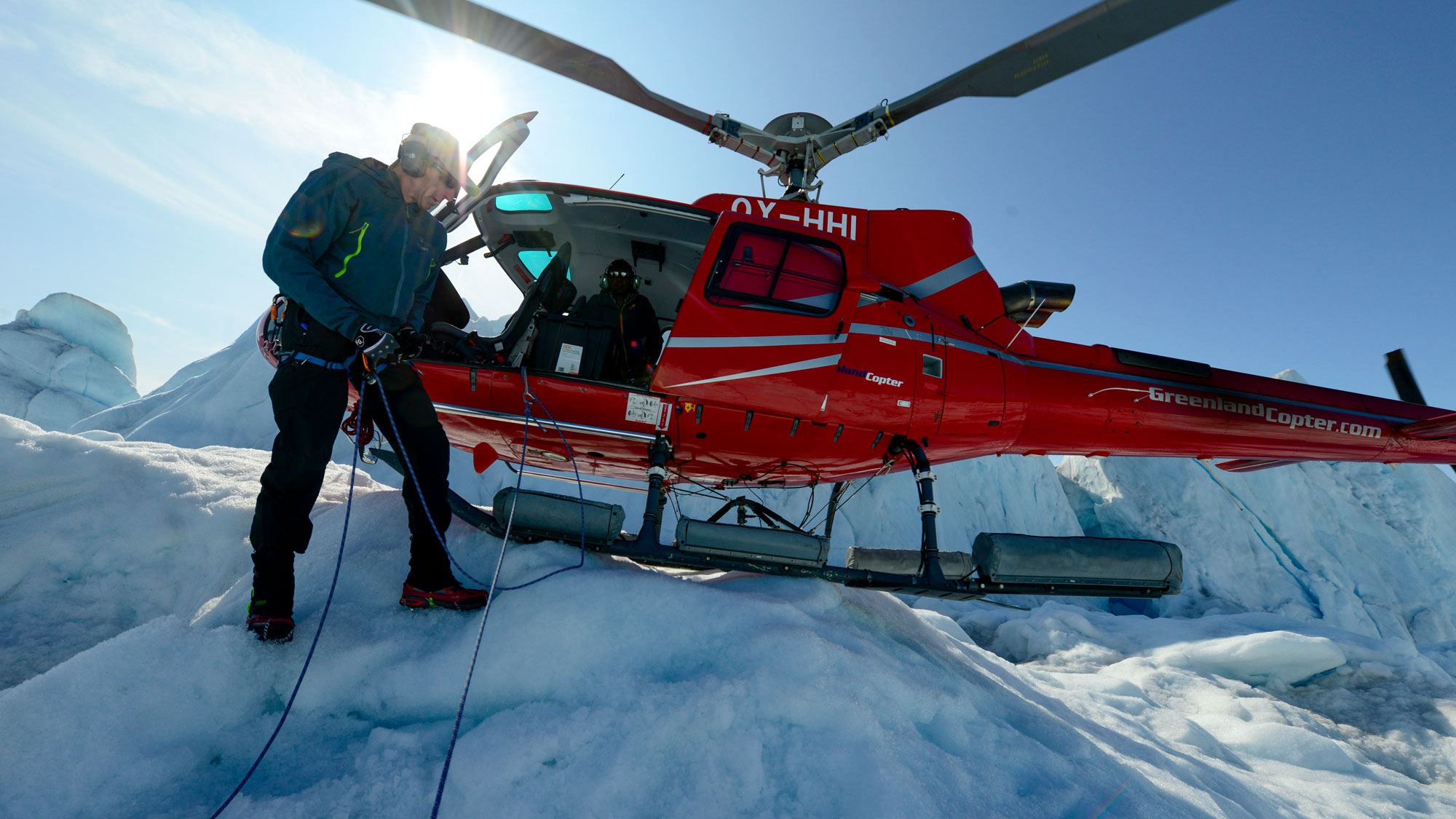
Over and over that day, the helicopter pilot descended to within centimeters of the cracked ice. Two tethered CRREL researchers hopped out. They drilled a hole, dropped in a geopebble handed to them by Anandakrishnan, and marked it with an orange flag. The devices would capture the seismic signals that shudder through the ice as it fractures—data that Anandakrishnan hoped to assemble into a 3D image of the underice channels that carry meltwater from its surface to the sea. The water "collects just like any river into larger and larger streams," he says, "until you have the Nile running down the bottom of Helheim."

First, Anandakrishnan needed to see whether his geopebbles worked. They were designed to transmit wirelessly so that a hovering drone could harvest their data. Two days after inserting the instruments, he and Marc Volpe, a gangly aerospace engineering student, took their homegrown drone out for a test flight. It looked the part: Two plastic pipes with a rotor on each end were strapped to a central metal axis about as long as a hockey stick. The landing gear was made of plastic foam.

The first few short test flights, launched from as close to the glacier as they could safely go, ended in a crash, or what Volpe called "an unintended rapid reconfiguration." The drone's simplicity meant it could be rebuilt, and by late morning of their second day, they were ready to send it out over the ice. "All clear," Anandakrishnan said. "No children or polar bears." But after skimming more than 1 kilometer over Helheim, the drone began to spin like a drunk, and they nearly lost it before the radio signal returned and they called it back.

Finally, the day waning, Anandakrishnan asked Volpe whether he wanted to try again. "It's not your drone, it's not your money," Anandakrishnan said. "Want to go for it?"

"Yeah, I think so," Volpe said.

The drone again started to fly sideways—but in the right direction. One kilometer passed. Two. "Come on!" Anandakrishnan yelled. Three kilometers. "Holy crap, it's there!" Volpe said. The drone hovered for a minute over the seismometer and then darted back toward home. "Did it connect to the pebble?" Volpe asked. Not only did it connect, Anandakrishnan said with glee, but "we got a big chunk of data."

C. BICKEL/Science

HOUSED IN A CONICAL GRAY TURRET on a fjord wall, an unending mass of rock and moss, an Atlas scanner watched the ice sheet decay. Below the laser scanner lay the camp that has been the CRREL team's summer home for the past half-decade. A nearby waterfall supplies drinking water, no filtration needed. A slanted rock slab offers dinnertime views of the sun setting over Helheim.

The team there felt Hamilton's absence keenly. "Gordon would have never allowed this," Finnegan said as he poured hot water into plastic bags of freeze-dried food. "He believed in a good meal after a hard, long day of fieldwork." The void was even more pronounced this year: Stearns, Hamilton's former student and successor, was on maternity leave.

One morning, the CRREL team clambered up a cliff to Atlas. CRREL geoscientist Adam LeWinter gave it a friendly twist to say hello. It whirred back to its rest position, gears growling at the interruption. The researchers cleaned, greased, and calibrated it while downloading data. They replaced a weather station and updated the batteries. Two reinforced vertical solar panels bracketed the device; several weather-protected black cubes contained methanol fuel cells for the long Arctic night. "The only fuel that doesn't freeze," Finnegan said. "But the exhaust does, which is problematic."

The dream of running Atlas year-round had proved elusive. During the summer, the two scanners work flawlessly, whirring to life every 6 hours. But each winter, they've found new ways to die. The team took bets on when the lasers would fail this winter. Ananda Fowler, a remote sensing scientist at CRREL, raised eyebrows with his forecast: They'd survive. "It feels good, man," he said. "I think this is the year."

The billions of data points, and counting, that the scanners have collected have proved hard to interpret. But the continuous measurements have begun to reveal, for example, the extent to which sea ice dropped by Helheim inhibits later calving and how crevasses open and spread. This summer, the lasers were trained on the ice around the open pool, tracking floating ice to gauge the upwelling plume's strength and watching to see whether the ice cliff was decaying faster than usual. In the past few years, the glacier has retreated so much that the scientists had to shift Atlas's field of view by 15° so that it could still observe the receding ice face.

Helheim was more active than the team could remember, cracking and grumbling. At the camp, heads popped up like prairie dogs each time a rumble and a whoosh signaled another collapse of ice into the open pool some 3 kilometers away. Within minutes, the force of the upwelling cleared the pool and stasis returned.

One day, a red helicopter clattered into view. The Jensen had docked at Tasiilaq the previous day; now, Straneo and others were collecting data from parts of the fjord the ship could not reach. They hovered near the ice, a mosquito against the white wall, getting a close view of the pool. Before they could sample, Helheim began to grumble, and the pilot shot away, landing at a safe distance on the sea ice. "I can't believe we set down on that berg," Jamie Holte, an oceanographer in Straneo's lab, said later. They ultimately flew back to the pool, and Helheim remained docile enough for Straneo to shoot a disposable probe into the water to measure temperature and salinity.

Afterward, the helicopter landed at the camp. The upwelling was astonishing, Straneo reported: "The warm water in the plume is all the way up to the surface." Later, data collected by a drifter showed that, for weeks, warm Atlantic waters had flowed 100 kilometers up the fjord and then welled up against Helheim's face. "It confirms this upwelling is driven by the glacier," Straneo said later, and appears to be playing a role in Helheim's demise.

"Ten years of work and this is what you get," she added, staring at a record of water temperature and salinity on her laptop, her voice a mix of pride and bemusement. The victory was hard-won after a disappointing end to their cruise. A second mooring, off the coast, hadn't resurfaced. And another attempt to recover the first mooring had failed.

Greg Hanlon, a researcher at the U.S. Army’s Cold Regions Research and Engineering Lab, prepares to drill a hole for a seismometer in Helheim’s ice. ADAM LEWINTER/U.S. ARMY ENGINEER RESEARCH AND DEVELOPMENT CENTER COLD REGIONS RESEARCH & ENGINEERING LABORATORY; REMOTE SENSING/GEOGRAPHIC INFORMATION SYSTEMS CENTER OF EXPERTISE

A CLEARER PICTURE of Helheim's dynamics, and how they relate to larger oceanic trends, is beginning to emerge from all the trial and error. For example, Straneo says that this summer, the data suggest conditions were unusual compared with those in recent years. Water temperatures in the fjord were "quite a bit warmer"—some 0.2°C above their previous high. "The moorings agree that we had a ramping up." A slightly warmer North Atlantic, it appeared, had conspired with the robust surface melting to intensify the warm plume at Helheim's face, potentially increasing calving.

The researchers have found that, in general, the warmth of the fjord's deep water tracks larger North Atlantic temperature swings. That finding suggests ocean measurements could help serve as a rough predictor of glacier retreat. Straneo and Donald Slater, a glaciologist and postdoc in her lab, have already used a model based on that connection to make a prediction: By 2100, one-quarter of Greenland's glaciers will retreat more than 10 kilometers, if emissions and ocean warming continue unchecked.

But, "We're still far from being able to make reliable projections," says Mathieu Morlighem, an ice sheet modeler at the University of California, Irvine, who is also working on the Helheim project. "If we don't get ice dynamics right at the coast, there's no way we get a decent projection."

Accomplishing that will take further scrutiny of Helheim. The lasers and replenished moorings will remain in place at least until 2022. Next year, the team will return with radar-equipped drones to map the topography beneath Helheim, looking for hidden slopes that could slow its retreat. Farther inland, they will continue to study trends in snowfall and melt by using satellite measurements and core samples of compacted snow.

The team will turn to computer modeling to unify all their observations: the seismic wiggles, the currents, the calving, the snowfall and ponding meltwater. Douglas Brinkerhoff, an ice sheet modeler at the University of Montana in Missoula, will write the code that pulls those observations together, adapting techniques from weather modeling to suck in data. Meanwhile, Morlighem will develop a high-resolution model to replicate just how multiple processes conspire to fracture the ice and erode the glacier's face.

"What I told Mathieu is, at the end, you need to be able to reproduce what Helheim has done," Straneo says. "And if we can explain this glacier, we should be able to scale up our understanding of the physics to other systems."

AFTER 3 DAYS with one Atlas, Finnegan's team moved to the opposite side of the fjord, to ready the second scanner for the winter. Then, a few days later, the scientists were gone, their instruments left behind. Meanwhile, Greenland continued to crumble, losing 329 billion tons of ice this year—a near record.

For now, Helheim endures. The Atlas lasers are keeping watch as the days shorten, whirring and dancing their invisible lights across the ice. And in the fjord, a lost mooring, holding fast to the murky bottom, records the signal of an ever-warming sea.

*Update, 15 October 5:30 p.m.: This story has been updated to include Leigh Stearns’s current affiliation.

This summer, the plume of ice melt and Atlantic water at Helheim's face opened up a vast pool that lingered for weeks.

VIDEOS: U.S. ARMY ENGINEER RESEARCH AND DEVELOPMENT CENTER COLD REGIONS RESEARCH & ENGINEERING LABORATORY; REMOTE SENSING/GEOGRAPHIC INFORMATION SYSTEMS CENTER OF EXPERTISE

Producer and Web Developer: Xing Liu  Supervising Producers: Alberto Cuadra, Beth Rakouskas  Photo Editor: Emily Petersen  Graphics Editor: Chris Bickel  Design Editor: Chrystal Smith  Video Editor: Meagan Cantwell  Editor: Tim Appenzeller